Newsletter Signup
The Austin Monitor thanks its sponsors. Become one.
Most Popular Stories
- Cap Metro to shelve 46 new electric buses for a year after manufacturer bankruptcy
- Mobility Committee hears public concern regarding expansion of MoPac
- Texas Attorney General Ken Paxton sues nonprofit that serves homeless in South Austin
- Red River music proponents see city funding as sign of support, progress
- City-owned Austin Studios found to have generated $2.6B in economic impact
-
Discover News By District

Environmental Commission fails to approve variance based on traffic concerns
Monday, July 9, 2018 by Jessi Devenyns
In a subdivision, how much density is too dense? Although not typically a question the Environmental Commission considers, it is one that became the crux of the discussion around a variance request at its June 20 meeting due to the traffic concerns that new development would create.
Although the city limits street crossings across critical water quality zones, Paul Linehan, the representative for the owners of 9406 Morninghill Drive, said that in this case, “We believe we deserve the variance.”
The commission, on the other hand, did not. The motion to approve the variance failed 5-3. Commissioners Linda Guerrero, Pam Thompson and Brian Smith voted against it. Commissioners Peggy Maceo and Marisa Perales were absent.
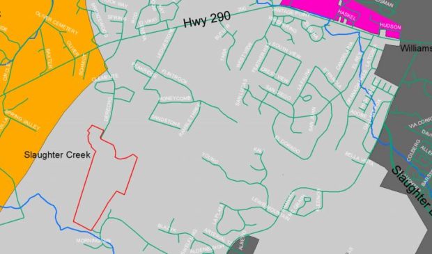
The owners of the property, which is two miles outside of city limits, asked for 165 acres of their 8,100 acres to be redeveloped into an 82-unit subdivision. Under the code, this density requires two points of access to the neighborhood. Due to its location, however, the second entrance will require a bridge to cross Slaughter Creek, a critical water quality zone. This requires a variance that Watershed Protection Department staff also did not support.
However, Environmental Officer Chuck Lesniak explained that this was a unique request.
According to Linehan, there is a private landowner between the owners’ two tracts of land who will not permit them to have a single outlet street to tie into FM 1826. With this limitation, after years of discussing the design in the Travis County Commissioners Court, the county directed the landowners to ask the city for a variance to build a bridge.
Commissioner Wendy Gordon argued that “there are already a good number of crossings from (U.S. Highway) 290 to MoPac (Expressway) and beyond.” In fact, there are nine in total between U.S. 290 and Brodie Lane in Southwest Austin.
Still, Linehan insisted that this bridge was more than just a crossing. He said it is also a solution to a potential health and safety issue associated with having a second entrance. This second access is heartily supported by the Oak Hill Fire Department that will need to drive emergency vehicles into the area. “Instead of it taking 17 minutes’ travel time … it goes from 17 minutes to six minutes with this bridge,” said Linehan.
The bridge itself would be 30 feet wide with a pedestrian crossing and a connection for public roads. However, according to Linehan, “it’s not meant to be a major connector between 290 and 1826.”
Even with his assurance, dozens of neighbors came and spoke to the commission for 45 minutes about their concerns regarding traffic if this subdivision is approved for development and the bridge is added.
Commissioner Andrew Creel thought differently. “I’m one of those people who looks for shortcuts when traffic is bad, and that would not be my choice,” he said. Still, he asked that traffic calming devices be considered.
Other commissioners were more concerned about the damage to the flood plain that the bridge would cause. They were reassured by Watershed staff, however. According to the design, when the bridge is complete, the landowners will restore 5.4 acres of flood plain to a “better condition” than it is in today.
To further improve the environment, Commissioner Katie Coyne asked if there was any willingness to exceed the water quality mandates, which are currently being met. In response, Linehan noted, “I’m sorry, but you’re talking to somebody who fought the (Save Our Springs) Ordinance pretty hard at the time.” Nevertheless, he said that he believes their concessions go above and beyond. “I believe it over-exceeds the SOS Ordinance as it is now,” he said.
The proposed recommendation, which did not pass, approved the plan but asked for conditions related to reducing traffic. The project will now proceed to the Zoning and Platting Commission with no recommendation for or against its environmental suitability.
Map courtesy of the city of Austin.
The Austin Monitor’s work is made possible by donations from the community. Though our reporting covers donors from time to time, we are careful to keep business and editorial efforts separate while maintaining transparency. A complete list of donors is available here, and our code of ethics is explained here.
You're a community leader
And we’re honored you look to us for serious, in-depth news. You know a strong community needs local and dedicated watchdog reporting. We’re here for you and that won’t change. Now will you take the powerful next step and support our nonprofit news organization?


