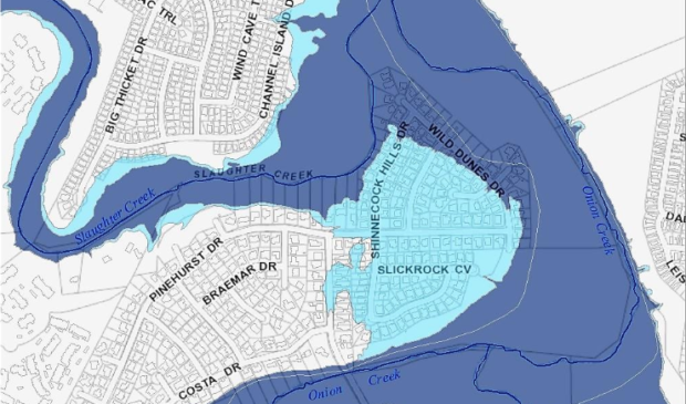
City’s new flood plain maps would affect building regulations
Friday, July 20, 2018 by
Chad Swiatecki New federal data on Austin’s rainfall patterns will cause the city to expand the size of areas in the 100-year flood plain and likely lead to a change in development requirements for properties exposed to flash-flooding risk.
The city’s Watershed Protection Department held its first public information session on the changes this week and also discussed them at a meeting of the Environmental Commission, with more sessions and presentations at commissions planned in the coming months. A public hearing and possible formal change to the city’s ordinances covering flood plain development practices are expected to take place in October.
The changes are a result of preliminary precipitation-frequency data from the National Oceanic and Atmospheric Administration, known as Atlas 14, that roughly found the city’s current 100-year flood plain of 10 inches of rainfall should become its 25-year flood plain, a 2.5-inch increase. Increasing heavy rainfall frequency also means the current 500-year flood plain level of 13.5 inches would be changed to the new 100-year flood plain, an increase of nearly 3 inches.
The federal data on the new, expanded 500-year flood plain is still being determined.
The practical result of those changes is that low-lying, flat areas that currently border flood plain areas would be formally recognized as being under increased threat of flash floods, with revised building requirements planned for properties and changes in flood insurance policies and premiums expected as a result within the next three years.
The suggested changes, which are still subject to revision, would require affected properties to have a safe access path at least one foot above the 100-year flood plain, leading to a nearby road that can be used for evacuation. Another change would require a citywide “free board” level where redeveloped flood plain properties would need to have the living space built two feet above the 100-year flood plain.
The proposed changes would also limit redevelopment to a maximum of 2,200 square feet, or the size of the existing structure if it exceeds 2,200 square feet. There would also be a prohibition on increasing the number of dwelling units on the property.
Currently there are 3,700 buildings located in the 100-year flood plain throughout Austin, many of them the result of construction prior to 1983 when the city began regulating building to prevent damage and safety hazards caused by flash flooding.
Kevin Shunk, Engineering Division manager for WPD, said the change to uniform code will allow development and building plans to mostly be approved administratively, removing some of the uncertainty and bureaucracy associated with flood plain properties.
“We have thousands of buildings already in the flood plain,” he said. “It is not possible for the city to get to all those buildings in all those areas to reduce those flood risks, so if we can incentivize people to do that on their own, then that’s a good idea because over time it will reduce the number of properties exposed in the flood plain.”
The updated flood plain information could have an impact on the selection and size of flood mitigation projects undertaken if voters approve a fall bond issue that includes $184 million for flood mitigation and open space.
“This study is confirming what we already suspected, that these storms or rain bombs we’re getting are getting heavier, and the rainfall record needs to reflect that,” said Matt Hollon, planning manager for WPD. “If the bond passes and we’re able to build projects that address existing problems, we would look at Atlas 14 from a design standpoint to handle those storms. It’s already a challenge with our current flooding structure, and this puts a lot more pressure on those projects.”
The city’s flood plain maps would be updated over a course of two or three years after the final data is compiled later this year. There is a possibility some properties in heavily affected areas would need to be bought out if there are no other options for keeping residents there safe if nearby creeks quickly flood.
“This will redefine flood plains, which means we’ll need to redefine the risk that those properties are at, identify projects that will mitigate that flooding, and implement those projects, whether they be buyouts, or tunnels or storm sewer systems. … It could be a number of things,” Shunk said.
Map courtesy of the city of Austin.
The Austin Monitor’s work is made possible by donations from the community. Though our reporting covers donors from time to time, we are careful to keep business and editorial efforts separate while maintaining transparency. A complete list of donors is available here, and our code of ethics is explained here.
You're a community leader
And we’re honored you look to us for serious, in-depth news. You know a strong community needs local and dedicated watchdog reporting. We’re here for you and that won’t change. Now will you take the powerful next step and support our nonprofit news organization?


