City adjusts flood map adjustment timeline
Tuesday, July 2, 2019 by
Jessi Devenyns The Atlas 14 study conducted by the National Weather Service indicated that in the immediate future, Central Texas is likely to experience more powerful storm events that will increase flooding by 30 percent. Last fall’s major floods turned scientific conjecture into observable reality. Now Atlas 14 has rendered the city of Austin’s current flood maps out of date.
Although the Watershed Protection Department originally anticipated it would present Council with comprehensive proposed code changes for flood maps this spring, according to a department memo last week, that timeline has been extended.
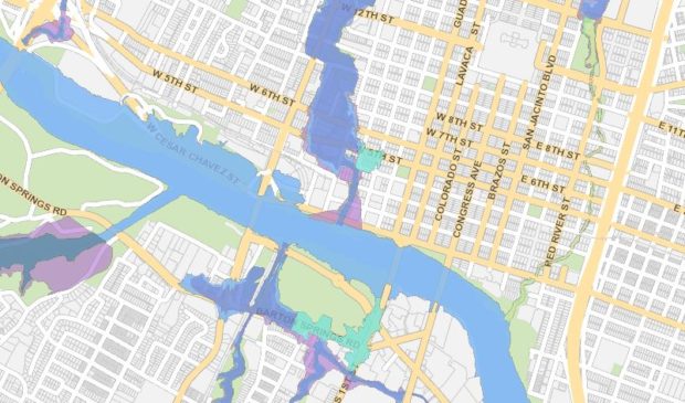
To remedy the incongruence between past and present, the Watershed Protection Department promptly proposed rolling out interim flood plain definitions that designated what was the pre-Atlas 14 500-year flood plain as the new 100-year flood plain and pre-Atlas 14 100-year flood plain as today’s 25-year flood plain.
The 100-year flood plain represents areas with a 1 percent chance or greater of flooding within the year and the 25-year flood plain is an area within a flood plain subject to a 4 percent or greater chance of flooding.
Now, after engaging residents, commissions and local real estate groups, Watershed Protection is anticipating code changes to come before Council in October.
In part, the altered timeline is due to the addition of three other revisions to the city’s flood plain regulations, including a new residential redevelopment exception to incentivize private investment to reduce the flood risk of existing residential buildings, an extension of the existing Colorado River exception to Lake Austin and portions of Lake Travis within the city’s jurisdiction and increasing the distance above the flood plain – called freeboard – for buildings 2 feet above the 100-year flood plain.
Currently, buildings are only required to be 1 foot above the flood plain, unless a building is in the central business district, where it must be out of the flood plain by 2 feet.
Kevin Shunk, the city’s flood plain administrator, told the Austin Monitor, “It’s been found that the single most effective way to reduce (flood) risk to a building is to elevate the building higher. So our idea was to reduce risk for buildings (and) make the building freeboard 2 feet across the city.”
However, the flood plain maps are only one piece of the puzzle. In tandem with the flood plain adjustments, the city will need to update the Drainage Criteria Manual (DCM) to reflect the new Atlas 14 rainfall values and the ability of current drainage infrastructure (e.g., detention and water quality ponds, engineered drainage channels and storm drain pipes) to accommodate the anticipated increase in rainfall.
With the extended timeline for the flood plain map implementation, the Drainage Criteria Manual revision process and presentation to Council will now occur three months after Council votes on the flood plain regulation revisions. Originally the Watershed Protection Department anticipated a 12-month gap between the vote on flood plain regulations and the drainage manual.
Shunk told the Monitor, “That rainfall data is used to size storm drain inlets, storm drain pipes, etc. So, the changes in the Drainage Criteria Manual won’t retroactively make us go back … and redo them all. The items that will be designed in the future will use the new rainfall data to incorporate in their design.”
While the adjustments to the Drainage Criteria Manual and the city’s flood plain regulations will be final, the flood plain definitions that will come before Council in the fall remain provisional. Completed flood plain map definitions are still a ways out. According to Shunk, the studies required to complete the new maps will take two to three years to complete. The maps will then be sent to the Federal Emergency Management Agency to be approved for use as new flood insurance maps as well as to the city for the official implementation as the new regulatory maps.
The first draft of the Drainage Criteria Manual revisions and the second draft ordinance for flood plain regulation amendments will come before the boards and commissions beginning in August. If all goes according to the anticipated timeline, Council will consider the proposed flood plain ordinances in October and the Drainage Criteria Manual revisions in December.
Atlas 14 flood plain map courtesy of the city of Austin.
The Austin Monitor’s work is made possible by donations from the community. Though our reporting covers donors from time to time, we are careful to keep business and editorial efforts separate while maintaining transparency. A complete list of donors is available here, and our code of ethics is explained here.
You're a community leader
And we’re honored you look to us for serious, in-depth news. You know a strong community needs local and dedicated watchdog reporting. We’re here for you and that won’t change. Now will you take the powerful next step and support our nonprofit news organization?


