Despite need for housing, ZAP does not approve Southwest Austin subdivision
Thursday, August 9, 2018 by
Jessi Devenyns After the Environmental Commission failed to recommend the environmental suitability of a densely planned Southwest Austin subdivision due to traffic concerns, the preliminary plan for this development proceeded to the Zoning and Platting Commission.
Much like the hearing in June, the case at Tuesday night’s Zoning and Platting Commission was greeted by a crowd of neighbors in opposition to the plan. The number of people who came to oppose the project at 9406 Morninghill Drive was so great that the commission had to move the proceeding to City Council chambers to accommodate the attendees.
Although the debate about the case lasted for hours and covered concerns from traffic to flooding to fire, the vote boiled down to the question of whether or not the scale of the project – the zoning allows for 30 lots with one access point, and the developer presented a plan with 82 single-family lots, which would require a second entrance to the subdivision – necessitated the variance for a bridge over a critical water quality zone. The commissioners found in an 8-1 vote that this was the case and so failed to recommend approval of this project. Commissioner Ann Denkler voted against the motion.
“We want a predictable code. This is how we get here: Apply it predictably,” Bobby Levinski from the Save Our Springs Alliance told the commission.
Paul Linehan, the representative of the applicant, saw things differently.
“Everybody here – you got what you wanted. You don’t want any change!” he turned to the public and screamed. “Just be fair. Quit turning us down because nobody wants any change. Things change!”
Although Commissioner David King voted against this plan, he did acknowledge that both the city and the applicants were in a sticky situation with this project. In Southwest Austin where the project is proposed, populations are growing, and there are increasing concerns with housing capacity. King said he appreciates that the project is trying to bring more homes to an area in need, but ultimately “the rules are the rules, and I think we need to follow the rules.”
The commissioners’ choice to adhere to the word of the code was in line with previous decisions made in the past around bridge variances. Atha Phillips from the Watershed Protection Department said that if the proposed bridge had been a high-traffic arterial street like MoPac Expressway or U.S. Highway 290, staff likely would have supported the variance. However, as the variance was for a private road to enter a neighborhood, staff considered it not “for the public good” and therefore considered the application differently. In her five years with the city as an inspector and an environmental review specialist, she said, “we have never permitted anything like this.”
Phillips, who was there to offer environmental expertise, explained that the watershed department wants to limit water crossing because “any disturbance is hard to recover from” and can cause water quality issues. She expressed concerns that if this variance was approved, “what’s to say this doesn’t set a precedent?”
Beyond environmental factors, concerns about building a cut-through bridge were expressed both by members of the commission and the public. Zyle Road resident Don Cash summed it up, saying, “I’m sure you’ve heard of something called the Y at Oak Hill. People will do anything to avoid that.” Unfortunately, neither the proposed bridge nor the roads it connects to are equipped to handle high traffic. Already the roads on either side are so narrow that cars cannot pass each other without one pulling off the road.
“We actually believe the bridge will create daily life-threatening safety issues against our children and the residents in these two neighborhoods,” said Erick Faul, a nearby resident.
Even with the testimony from the public, the commission explained that granting the variance was not a question of traffic concerns, but rather of the applicant’s inability to prove that the variance was not necessitated by the project’s scale. Until they can do so, this 164-acre lot will remain restricted to its initial single-entrance, 30-lot development entitlement.
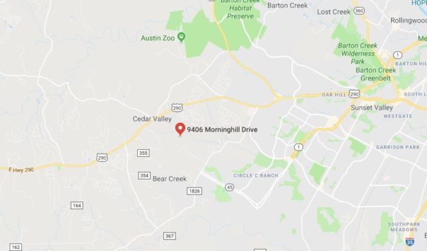
Map courtesy of Google Maps.
The Austin Monitor’s work is made possible by donations from the community. Though our reporting covers donors from time to time, we are careful to keep business and editorial efforts separate while maintaining transparency. A complete list of donors is available here, and our code of ethics is explained here.
You're a community leader
And we’re honored you look to us for serious, in-depth news. You know a strong community needs local and dedicated watchdog reporting. We’re here for you and that won’t change. Now will you take the powerful next step and support our nonprofit news organization?


