
The Austin Transportation Department published a report this week analyzing the traffic impacts of future mobility scenarios for downtown’s Rainey neighborhood.
“The popularity of the Rainey Street entertainment district has led to mobility challenges and concerns over interactions between pedestrians, bicyclists, people riding scooters and people driving vehicles, with residents expressing frustration at increasing congestion,” stated the department’s newsletter this week.
The Rainey Mobility Study modeled traffic impacts for 11 scenarios based on traffic volumes expected by 2025. Although the report does not include any final recommendations, it identifies several improvements that may be further developed and included as part of the Austin Core Transportation Plan, a downtown mobility plan being prepared for release late this summer.
Of the 11 scenarios that were modeled, one provided the most benefit in terms of minimizing vehicle delay and improving traffic circulation.
That scenario entails adding a traffic circle at the intersection of Davis and Red River streets, extending Red River Street south as a two-way north-south connection, installing all-way stop controls at East Avenue and River Street and at Driskill and Red River streets, and connecting Rainey Street to Cesar Chavez Street.
Like most of the scenarios considered, it also proposes permanently closing Rainey Street to non-emergency vehicle traffic between Driskill and River streets.
The department is currently conducting the Rainey Shared Streets Pilot to determine the traffic impacts of closing Rainey Street to vehicular traffic on weekend evenings. The pilot launched on Dec. 5, 2019, and will end on March 8. Along with the mobility study, the pilot will inform the Rainey neighborhood component of the Core Transportation Plan.
“Closing Rainey Street to vehicles would improve the space for pedestrians, bicycles and micromobility,” the report states. “However, vehicle circulation would need to be maintained via other routes within the study area, including the Red River extension.”
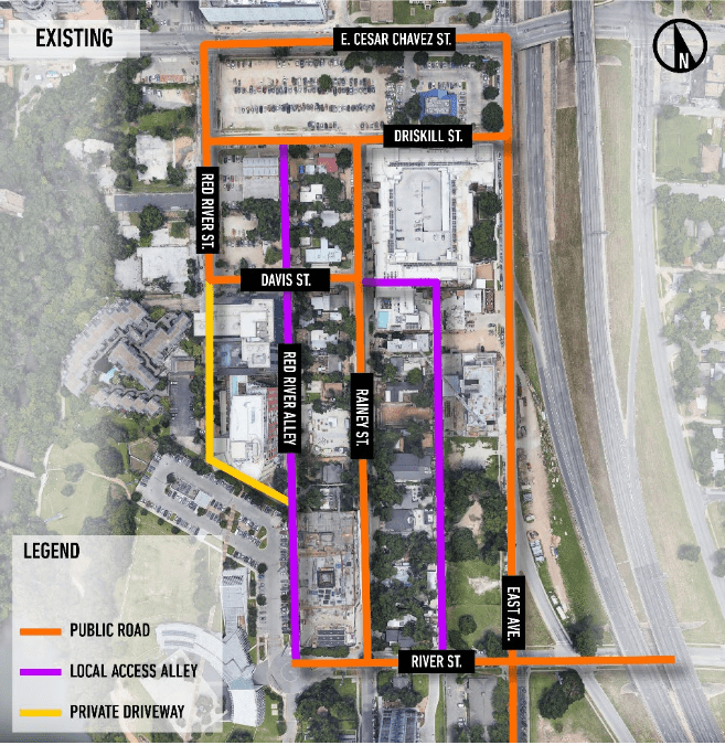
The extension of Red River Street would require conversion and expansion of what is currently a private driveway used by the Shore Condominiums and Kimpton Hotel Van Zandt. The two-way street would flow north-south to the west of the private properties between Davis Street and the Mexican American Cultural Center. The street would cut east at the cultural center and connect with Red River Alley, an alley between Davis and River streets that would be widened and used for two-way north-south traffic.
The study considered two primary network changes: the Red River Street extension and vacation of the Red River Alley south of 70 Rainey Street. Based on the study results, the report recommends using the alley for two-way traffic instead of vacating it for local use.
The developer at 70 Rainey had previously proposed to vacate the alley and create another east-west alley to be used in part as a gateway to the Mexican American Cultural Center. The new alley has been constructed, but City Council has not vacated the north-south alley.
Since getting a zoning change from a primarily low-density residential area to part of the Central Business District in 2004, the neighborhood’s lack of street connectivity has become a major complaint from Rainey neighbors and employees.
The Rainey Mobility Study was conducted by multinational engineering firm AECOM. The study area was smaller than the Rainey neighborhood district, bordered by the Interstate 35 frontage road, Red River Street, East Cesar Chavez Street, and River Street, where the entertainment district is most concentrated.
In addition to the identified improvements, the report notes the potential for curb management techniques to reduce distances between curbs and create a safer pedestrian environment while allowing for better vehicle circulation with designated spaces for loading zones and other uses.
The report also states the need for a district-wide parking strategy, such as the underground parking garage foreseen by the Mexican American Cultural Center master plan, which would nearly double the district’s total parking capacity.
Finally, the report states that the proposed option to run the Project Connect high-capacity Blue Line across Lady Bird Lake with a new Trinity Street bridge could allow for a connection to the neighborhood, substantially increasing the neighborhood’s access to public transit.
Map and rendering courtesy of the city of Austin.
The Austin Monitor’s work is made possible by donations from the community. Though our reporting covers donors from time to time, we are careful to keep business and editorial efforts separate while maintaining transparency. A complete list of donors is available here, and our code of ethics is explained here.