ICRC continues to request feedback in final month of district mapping
Monday, September 27, 2021 by
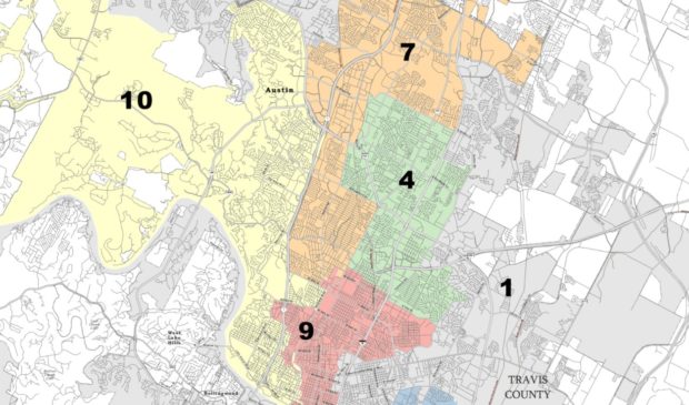
Willow Higgins The Independent Citizens Redistricting Commission continues to gather public feedback on the preliminary map commissioners helped draw of Austin’s City Council districts. While commissioners approved a preliminary map on Sept. 15, they have until Nov. 1 to consider additional feedback from Austinites and approve a final version. So far, the district map looks relatively similar to the previous Council map from 2013, and most citizen feedback has been positive.
After the preliminary map was approved, the ICRC began a series of forums, to be held over the course of two weeks, to collect additional public comment. This comes after the commission spent the summer months acquiring initial feedback from Austin residents. The city’s 10 districts are supposed to be roughly equal in population size, per the city charter. The district boundaries must be updated every decade to reflect the city’s evolution, using census data to influence adjustments.
Luis Gonzalez, the ICRC’s vice chair, said at a forum this week nearly all public testimony received was positive and in agreement with the proposed changes to the map. This version of the map will continue to evolve in response to feedback through October.
Gonzalez said most citizens who are unhappy with the current map are either concerned about a district border line dividing a community or don’t feel like the district their neighborhood has been shifted into represents the area.
“We just try our best to educate that (that) may happen, but also to let them know splitting the neighborhood is not something that we want to do,” Gonzalez said. “Nobody wants to split a neighborhood. Nobody wants to take out someone’s favorite grocery store away from their district. And that’s the whole purpose of these forums.”
The commission heard similar feedback at its first meeting after the preliminary map was approved on Sept. 18. Several attendees advocating for East Austin’s District 1, a historically Black and Hispanic area, expressed concern about expanding the district west of Interstate 35 and incorporating the old Brackenridge hospital, which is just west of the highway, into the district. Residents from both districts 9 and 1 said that the 14-acre area is under significant development and belongs downtown in District 9.
District 1 advocates also argued that the only areas west of I-35 that belong in their district are the LBJ Presidential Library and the LBJ School of Public Affairs, a desire that was reflected in the 2013 map as well as the current preliminary map.
The school and library’s inclusion serves “as a reminder of the importance of allies and how far we have come and how far we have yet to go in this city,” said Ora Houston, a former Council member from District 1.
Other points of concern include a proposed shift of the Bryker Woods neighborhood from District 9 to District 10; the division of the Old Enfield neighborhood into multiple districts; and splitting a downtown voting precinct into two Council districts (which residents argue could confuse voters).
Commissioners are working to address all of these concerns, although they acknowledge they might not be able to make everybody happy.
The commission has also heard feedback that changes made to District 6 dilute the conservative voice in the area. Gonzalez explained that while that was not the commission’s intention, as an apolitical body the ICRC cannot address that type of feedback.
The commission is bound to the mapping priorities ranked in the city charter. Each district should:
- have a roughly equal population size
- comply with the federal Voting Rights Act, which protects areas with high numbers of minority voters
- be geographically contiguous
- respect communities of interest by minimizing their division
With the above priorities in mind, the ICRC will continue to request participation in three more forums scheduled through Oct. 2. The commission will then use compiled feedback to create a first draft of a final district map, which they will show to the public in mid-October. At that point, the commission will host three more forums for final feedback, and will ultimately approve a final map by Nov. 1. Public comment may also be submitted to the commission via email or snail mail at any time, detailed here.
The Austin Monitor’s work is made possible by donations from the community. Though our reporting covers donors from time to time, we are careful to keep business and editorial efforts separate while maintaining transparency. A complete list of donors is available here, and our code of ethics is explained here.
You're a community leader
And we’re honored you look to us for serious, in-depth news. You know a strong community needs local and dedicated watchdog reporting. We’re here for you and that won’t change. Now will you take the powerful next step and support our nonprofit news organization?


