Key Players & Topics In This Article
Austin Strategic Mobility Plan
City of Austin Parks and Recreation Department: The city department responsible for the city's park system, rec centers, and associated infrastructure.
Austin failed to install directional signs, also known as wayfinding, on all urban trails by 2022, a specific target outlined in the city’s far-reaching transportation strategy.
The Austin Strategic Mobility Plan was adopted unanimously by the City Council in 2019. The ASMP – two years in the making, involving the input of thousands of Austinites – is supposed to guide city officials on everything from land use and parking to sidewalks and aviation.
The plan has almost 300 specific goals to reach over 20 years. But only one objective specifically lists 2022 as the completion date: installing wayfinding elements on 100 percent of existing urban trails.
Austinites value urban trails. Since 2016, voters have approved more than $100 million in city debt to build more of the wide, paved, multi-use paths that connect with on-street bikeways and sidewalks. Each new mile of urban trail costs up to $4 million, including wayfinding.
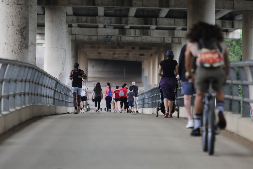
Jorge Sanhueza-Lyon/KUT. The MoPac pedestrian bridge is part of Austin’s 60-mile network of urban trails.
The signs help people navigate the publicly funded system. Hikers trekking along nature trails or mountain bikers shredding through the woods, for example, might pop out onto a paved urban trail and not know where they are.
Smartphones have maps. But not everyone has a smartphone. Some people don’t want to stare at a screen while on a walk. Signal strength isn’t always great. Cyclists have limited use of their hands while riding.
“I like signs,” said Chris Coxwell, who was riding her bike along the Southern Walnut Creek Trail, which does have wayfinding. “I think signs are good. They tell you where you are, what’s coming up.”

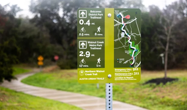
City of Austin. An image from a city presentation showing the difference between wayfinding signs and mile marker signs on the Southern Walnut Creek Trail.
But the person who leads the four-person Urban Trails Program couldn’t say off the top of her head how many of its 60 miles of urban trails have the handy directional signs with maps and travel times to various destinations.
“It’s a target that we want to hit if we had all the resources and capacity available to us,” Katie Wettick said. “But I think that there’s other stronger measures of success, especially with the focus on projects and getting more trail infrastructure in the ground.”
Wettick says since 2014, when the first Urban Trail Plan was adopted, the city has added some 30 miles of urban trails, or about half the existing network. Those 30 miles include some shared-use paths along highways that connect to the larger trail system.
When new pieces of trail are built, wayfinding is added to that segment and the stretches of trail next to it. Wettick says wrapping the wayfinding into a larger project makes more efficient use of bond dollars.
“I think it’s a question of making sure that we’re putting wayfinding where people need it, where it really is useful, and not just trying to hit this arbitrary 100 percent goal,” she said.
More signs will be going in on the Shoal Creek Trail in the coming months. But Country Club Creek Trail, which has a mile-long gap, won’t get wayfinding until construction starts on a missing segment in about a year.

Nathan Bernier/KUT. A mile marker sign on the Shoal Creek Trail. Wayfinding signs should be going in along the Shoal Creek Trail in the coming months.
Austin is taking public comments on a new plan to guide urban trail-making for years to come. One action item in the proposal calls for developing a wayfinding plan for all existing and proposed urban trails.
You can offer feedback on the draft plan until March 20.
This story was produced as part of the Austin Monitor’s reporting partnership with KUT.
The Austin Monitor’s work is made possible by donations from the community. Though our reporting covers donors from time to time, we are careful to keep business and editorial efforts separate while maintaining transparency. A complete list of donors is available here, and our code of ethics is explained here.
And we’re honored you look to us for serious, in-depth news. You know a strong community needs local and dedicated watchdog reporting. We’re here for you and that won’t change. Now will you take the powerful next step and support our nonprofit news organization?
Austin Strategic Mobility Plan
City of Austin Parks and Recreation Department: The city department responsible for the city's park system, rec centers, and associated infrastructure.

