Sections

About Us

 
Make a Donation
Local • Independent • Essential News
 
Photo by Nathan Bernier/KUT News. Construction is scheduled to start this summer on the biggest expansion of I-35 in Austin's history. The project includes tearing down the upper decks, rebuilding east-west bridges and adding at least four lanes in each direction along an 8-mile stretch of highway from U.S. 290 East to Ben White Boulevard.

Your ultimate guide to the I-35 expansion through Central Austin

Friday, February 23, 2024 by Nathan Bernier, KUT

Austin’s Interstate 35 – the spine of the region’s roadway grid – is about to undergo the largest expansion since the highway opened in 1962. Brace yourself: Construction could last a decade.

This time it’s for real. The money – at least $4.5 billion – has been set aside. The Texas Department of Transportation is willing to draw from future road projects if it needs more cash. Road building companies will start bidding on contracts this spring. Construction is planned to kick off this summer unless a lawsuit stops it.

The project is officially known as I-35 Capital Express Central, or I-35 CapEx Central for short. And it is seriously big.

The highway’s new footprint will devour 54 acres of land, forcing out more than 100 homes and businesses. I-35’s increased capacity will bring more urban sprawlair pollution, climate-warming gases and noise.
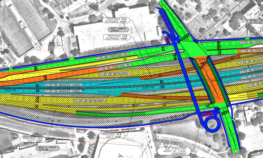
An engineering schematic for I-35 expansion. It is a color-coded map overlaid on an aerial photograph, showing various aspects of a highway system. Most of the area shown is just north of the Martin Luther King Jr. Boulevard bridge over I-35.

TxDOT. I-35 will grow from 16 to 22 lanes in one section of downtown Austin. This schematic is oriented so that north is to the left.

But what exactly is happening with the highway?

This is a walkthrough of TxDOT’s on-road plans along the 8 miles of I-35 bounded by Ben White Boulevard to the south and up to U.S. Highway 290 East to the north. Before we dive into the details, let’s hit the high points.

TxDOT says it will:

  • Build two extra “managed lanes” in each direction from Ben White Boulevard to U.S. 290 East. The managed lanes – in this case, high-occupancy vehicle (HOV) lanes – would be restricted to first responders, public transit vehicles, and cars or trucks with more than one person inside. Local and state police would be responsible for enforcing the vehicle occupancy minimums.
  • Tear down the upper decks that run from Manor Road to Airport Boulevard.
  • Sink the main lanes 30 feet to 40 feet below ground level from Holly Street to Airport Boulevard.
  • Install “caps” covering parts of the sunken highway – essentially creating an I-35 tunnel through downtown Austin – but only if Austin and the University of Texas foot the bill. The cost for the city alone could reach close to $900 million, not including tens of millions of dollars in annual maintenance expenses.
  • Narrow the main lanes from 12 feet wide to 11 feet.
  • Build at least 14 widened east-west vehicle bridges and at least seven stand-alone pedestrian bridges.
  • Construct larger interchanges at Riverside Drive and Airport Boulevard.
  • Eliminate the car crossing at Woodland Avenue.
  • Make north- and southbound frontage roads run side-by-side through downtown and much of the UT area.
  • Add more than 20 miles of “shared-use paths,” which are basically 8-to-10-foot-wide sidewalks that often include a 2-foot-wide curb.
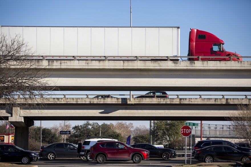
A ground level view of the upper decks of I-35 as seen while standing on 39th Street facing east. The perspective is set up so that three levels of vehicles are visible. The ground level frontage roads, the northbound main lanes and the closer southbound main lanes above that.

Gabriel C. Pérez/KUT News. Say goodbye to the upper decks. These elevated lanes opened in 1975. They’ll be torn down and the highway will be widened into neighboring properties.

There’s so much more to this project, including plans to build a large drainage tunnel under Cesar Chavez Street. If you want to get into the weeds, TxDOT has thousands of pages of documents. We merged many of those docs into a single PDF that’s almost 9,000 pages and more than 1 GB. You might also be interested in 10,000 pages of public feedback.

With the basics out of the way, let’s get a closer look at I-35 CapEx Central. First, a quick heads-up on what you’re about to see. If you want to jump ahead, here are links to specific sections.

The designs are still being tweaked, so these plans have changed in some ways. We’ll get to that. And the highway is rotated in these images. Left is north, down is west and so on.

The schematic maps have lots of different colors in them. Here’s TxDOT’s legend explaining what each means. Don’t be intimidated. You don’t need to know all this.

The image is a legend from the I-35 CapEx Central schematics. It shows various line styles, colors and patterns that correspond to different features such as proposed roads, existing right-of-way, environmental study areas, types of lanes, noise barriers, bridges, paths and so on.

TxDOT. This legend shows how to interpret most of the TxDOT schematics shown in this story.

But you should know that “ROW” stands for right of way. You could think of this as the footprint of the highway. The dotted orange line is the right of way now. The dotted light-blue line will be the new right of way.

We’ll start our tour at the far southern end of the I-35 CapEx Central project, because this is the portion scheduled to be constructed first.

Ben White Boulevard to Lady Bird Lake

A drone shot of I-35 looking northbound from just north of Ben White. The city skyline can be seen in the background. Visible between the mainlanes of the highway is the additional space that will be used for managed lanes.

Nathan Bernier/KUT News. I-35 north of Ben White Boulevard already has space between the main lanes that will be devoted to the new managed lanes.

The managed lanes – two in each direction – are shown on the inside of the highway. The blue lines are sidewalks (also known in this context as shared-use paths) that are at least 8 feet wide. TxDOT says some existing sidewalks may be kept; a blue line doesn’t necessarily indicate a new shared-use path.

TxDOT's schematic overlayed on an aerial photograph of Ben White Boulevard at I-35. Blue lines show shared use paths planned for the project.

TxDOT. The I-35 CapEx Central project starts at Ben White Boulevard. The new managed lanes are shown in the middle of the highway, separated by a 4-foot buffer from four main lanes. The blue lines are shared-use paths. Not all blue lines indicate new construction. Some existing sidewalks may be kept.

At Ben White Boulevard, the I-35 CapEx Central project will merge into the I-35 CapEx South project, which is already under construction. TxDOT is building two elevated lanes in each direction from Ben White Boulevard almost to Slaughter Lane. The full CapEx South project extends to the Travis County border with Hays County.

An illustration showing two elevated lanes in each direction running down the middle of I-35.

TxDOT. A TxDOT illustration from a 2020 presentation showing what the elevated lanes could look like south of Ben White Boulevard.

Freeway lanes along the entire I-35 CapEx Central project would narrow. Main lanes would be 11 feet wide instead of their current width of 12 feet. Managed lanes would also be 11 feet wide. TxDOT says it’s doing this so it won’t have to take more land than the 54 acres already being expropriated.

Narrower lanes tend to make people drive more slowly, so they’re often encouraged on city streets. But high-speed, high-volume freeways with lots of semi-trucks usually have 12-foot wide lanes. TxDOT’s own standards call for 12-foot-wide lanes for freeways. So do federal guidelines defined by the American Association of State Highway and Transportation Officials.

A Texas A&M University study of highways in Dallas, San Antonio and Houston found people drove about 2 miles per hour slower in 11-foot-wide lanes than 12-foot-wide lanes. But narrower lanes tended to result in more crashes causing injury or death, the study found.

A technical drawing showing the cross-section of I-35. The layout of lanes, including their widths, is shown from a side-view. Starting from the left, there is a 10-foot wide shared use path followed by a 2-foot wide curb. Next are three 12-foot wide lanes for the northbound frontage road followed by a 16-foot wide shoulder. Then we get to the main part of the freeway. From left to right, it starts with a 10-foot shoulder, followed by four lanes that are each 11 feet wide. A four foot buffer separates those northbound mainlanes from the two northbound managed lanes. Each managed lane is 11 feet wide. There's a four-foot buffer on the inside of the managed lanes before a 20-foot median. Then the pattern repeats in reverse on the southbound side. A 4-foot wide buffer is followed by two managed lanes, each 11 feet wide. There's another four-foot buffer and then four mainlanes that are each 11 feet wide. A ten-foot shoulder follows. The southbound frontage road is shown as having a 6 foot shoulder, three lanes that are each 12 feet wide, a 2-foot wide curb and then a 10-foot wide shared use path.

TxDOT. This cross-section of the I-35 expansion plans at Ben White Boulevard shows the width of each component. The sidewalk or “shared-use path” is 10 feet wide with a 2-foot-wide curb. Frontage roads lanes are 12 feet wide. The main lanes and managed lanes are all 11 feet wide.

The cross-section shows the layout of the highway at this point. The managed lanes would be 4 feet away from the main lanes. That buffer is intended to reduce the risk of side-swipe crashes, among other purposes.

Frontage roads along the project’s length are 12 feet wide from Ben White Boulevard until some point north of Oltorf Street. One foot might not sound like much, but it feels a lot different while driving.

Sidewalks throughout the project vary in widths between 6 feet wide and 14 feet wide. The most common widths shown in the cross-sections are 8 and 10 feet.

At Woodward Street, the bridge would remain unchanged. This and the Oltorf Street crossing are the only two major east-west bridges that wouldn’t be widened as part of the I-35 CapEx Central project.

The Oltorf Street bridge was already expanded in 2020 as part of a $43 million project spanning from Woodland Avenue to Woodward Street.
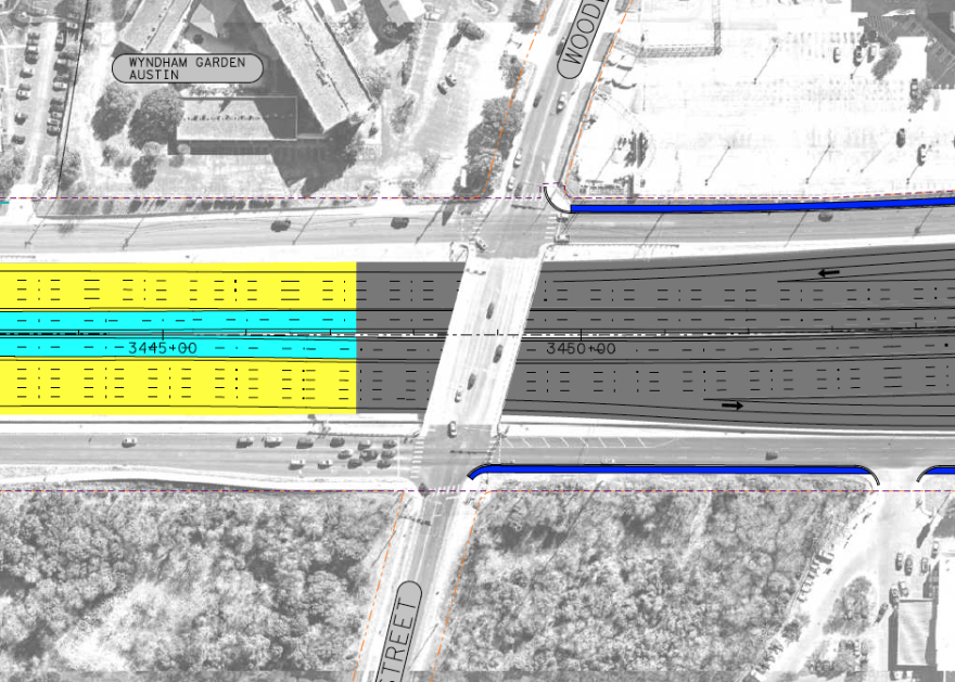
An aerial view of the schematic at I-35 and Woodward. Blue lanes indicating shared-use paths are shown south of the Woodward Street Bridge.

TxDOT. The Woodward Street bridge over I-35 is one of two major bridges along the CapEx Central project that won’t be getting an upgrade. The other is the Oltorf Street bridge, which was expanded in 2020.

The blue lines represent sidewalks. Some of the sidewalks on the southbound frontage road south of Woodward Street have been labeled “functionally deficient” by the city, meaning they’re not good enough to use safely or easily. TxDOT says those would be rebuilt.

From Oltorf Street to Woodward Street, the pavement of the I-35 main lanes would be upgraded from asphalt to concrete. Concrete is more expensive than asphalt, but it’s more resistant to weather, supports heavier loads without grooves forming in the pavement and absorbs less heat. Asphalt is easier to recycle and has a smoother, quieter ride than concrete until it ages and hardens.

Moving farther north in the schematic view (remember, left is north), the northbound exit to Oltorf Street would remain the same as it is now. The exit ramp travels under the entrance ramp. These ramps that cross over each other are called “braided ramps.”
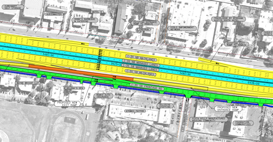
This I-35 schematic shows the northbound exit to Oltorf Street staying as is. The southbound exit lane would pass under a new southbound entrance lane, which would be elevated as a bridge, shown in orange. The light-blue managed lanes would continue down the middle of the highway.

TxDOT. This I-35 schematic shows the northbound exit to Oltorf Street staying as is. The southbound exit and entrance lanes would cross over each other as “braided ramps.” The light-blue managed lanes continue down the middle of the highway.

Another braided ramp is planned south of Oltorf for drivers trying to get on I-35 southbound. This would mean tearing up some pavement installed just a few years ago as part of the I-35 at Oltorf Street project. The ramp along the highway would also be affected.

Most of the work on the I-35 at Oltorf Street project would remain, however, including the Oltorf Street bridge over I-35. TxDOT already added north and south U-turns and created more space for pedestrians and cyclists.

But even after the Oltorf Street bridge upgrade in 2020, people on foot still have to cross “slip lanes” without any traffic signal. Slip lanes are those right-turn lanes that let drivers quickly bypass the normal intersection to turn right. They’re convenient for drivers but can be dangerous for pedestrians.

Because they’re designed to keep cars moving quickly, drivers often assume they have the right of way over pedestrians. Sometimes the angle of a slip lane makes it harder to see a car coming.

When asked whether the slip lanes along the I-35 CapEx Central project would have pedestrian crossing signals, TxDOT spokesperson Brad Wheelis said the agency is “in the design process for pedestrian access.”

An overhead schematic view showing Oltorf Street crossing I-35.

TxDOT. The Oltorf Street bridge was widened in 2020 as part of a $43 million project. The I-35 CapEx Central plans don’t call for many changes to the bridge.

TxDOT is attempting to spruce up the look of the new highway with what it calls the CapEx Central Aesthetics Design Program. The state agency held public meetings and proposed ideas. Employees are incorporating some of that feedback, so final decisions haven’t been made.

For the Oltorf Street bridge, different aesthetic scenarios were floated at a public meeting in January 2023. The concepts included benches, shade, landscaping and an “art wall.” We’ll see more of these proposals throughout this walkthrough.

An illustration of the intersection of I-35 at Oltorf Street. Crosswalks are shown as red paths with white outlines. The sidewalks have street furniture, trees, and landscaping. A colorful geometric mural is shown on the Oltorf Street Bridge.

TxDOT. This was one of several TxDOT proposals for what the Oltorf Street at I-35 area could look like. The image includes street furniture and a shade structure, red pedestrian crossings and an “art wall” along the Oltorf Street bridge.

Your first change to get on or off the managed lanes in this part of CapEx Central wouldn’t be till north of Oltorf Street. People driving northbound could exit the frontage roads for Woodland Avenue. Southbound drivers could enter the managed lanes just north of Woodland Avenue or get on the main lanes a little farther south.

An overhead view of the schematic showing I-35 around the Mariposa Drive area. Orange lines depict bridges leaving the northbound managed lanes to reach the frontage roads and entering the southbound managed lanes.

TxDOT. TxDOT plans to build a “wishbone ramp” – a flyover ramp that connects the inside lanes of the freeway directly to the frontage road – north of Oltorf Street and south of Woodward Avenue. These are the first entrances to and exits from the managed lanes in the southern portion of the I-35 CapEx Central project.

The general purpose lanes would be lowered here. The managed lanes would be at about the same level as the frontage roads.

A cross-section of I-35 near Woodland Avenue shows the new configuration, with lowered general purpose lanes and the managed lanes running at about the same level as the frontage roads.

TxDOT. A cross-section of I-35 near Woodland Avenue shows the new configuration, with lowered general purpose lanes and the managed lanes running at about the same level as the frontage roads.

The highway’s footprint widens on both sides north of Oltorf, as shown by the dotted light-blue line. This will require demolishing businesses at I-35 and Mariposa Drive.

A gas station, a river tubing company called ATXCursions and Jimmy’s Barbershop will be forced out. On the other side of Mariposa, the convenience store/gastropub Whip In and Travis Heights Wine & Spirits next door will be spared, but their parking lot will be shaved off.

An aerial view showing how close the Whip In is to I-35. The frontage road runs directly in front of the business's parking lot.

Nathan Bernier/KUT. Whip In and neighboring Travis Heights Wine & Spirits will lose their front parking lot to the I-35 expansion. Businesses on the other side of Mariposa Drive will be forced to move.

At Woodland Avenue, cars will no longer be able to cross I-35. A 75-foot-wide pedestrian and bike bridge will be built instead. But this publicly released schematic is out of date.
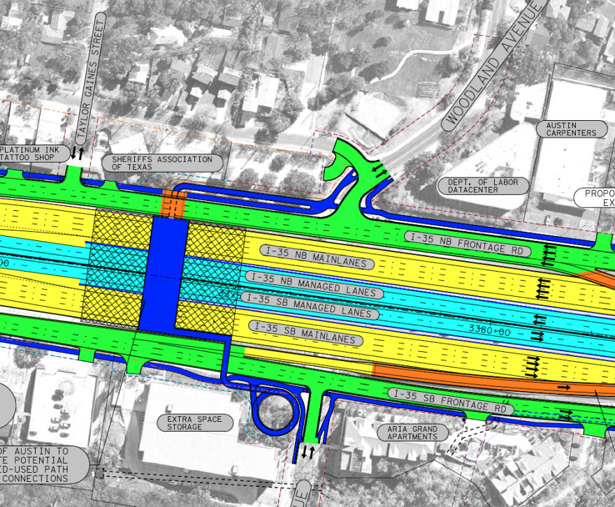
A schematic view of I-35 at Woodland Avenue. The car crossing over I-35 is gone and replaced with a pedestrian bridge, indicated in blue. This bridge is not aligned with Woodland Avenue; it's further north and includes a tunnel under the frontage road.

TxDOT. The I-35 schematics published in September show the Woodland Avenue pedestrian bridge misaligned with the street grid. The crossing would have had a pedestrian tunnel under the I-35 frontage road. New plans do away with the tunnel and push the bridge closer to Woodland.

TxDOT’s latest plans have the Woodland pedestrian bridge running more in line with Woodland Avenue instead of being offset from the street grid.

An overhead illustration showing the 75-foot wide pedestrian bridge at Woodland more closely aligned with the street grid. The bridge appears to be only a few yards north of Woodland. There is no more tunnel.

City of Austin. After hearing complaints from residents and the city of Austin, TxDOT moved the planned Woodland Avenue pedestrian bridge closer to Woodland. This is a rough diagram by the city. The latest TxDOT schematics haven’t been made public, but they show a configuration similar to this.

City Council considered but rejected a plan to spend at least $15 million on a 300-foot-wide bridge at Woodland. TxDOT will pay for the 75-foot-wide pedestrian bridge and says it might look something like this.

An illustration of the pedestrian bridge near Woodland Avenue. The scene is at night and several people are milling about. The bridge is about 75 feet wide with some benches and a shade structure. Some people are milling about. One woman in athletic wear has a baby stroller. One couple appear to be looking at traffic on I-35.

TxDOT. An illustration of what the 75-foot-wide pedestrian bridge over I-35 at Woodland Avenue could look like.

As I-35 makes its famous turn toward downtown where Austin’s skyline comes into focus, the highway’s footprint continues to widen. The number of lanes – including frontage roads but not ramps – would grow from 11 to 21. In addition to the new managed lanes, I-35 would have four main lanes in each direction here instead of three.

A schematic of I-35 just south of Riverside Drive

TxDOT. Drivers could access “bypass lanes” to stay on the frontage road and skip the new interchange planned for Riverside Drive. A sidewalk on the southbound side of the highway is shown going over the frontage road on a bridge.

.

At Riverside Drive, TxDOT plans to build something called a “single-point urban interchange” or SPUI (pronounced SPOO-ee). A SPUI allows all left-hand turns to be controlled by a single traffic signal and can move certain types of traffic more quickly.

An aerial view of the schematic of I-35 at Riverside Drive. The schematic shows a single-point urban interchange along with several new pedestrian paths.

TxDOT. I-35 at Riverside Drive and Airport Boulevard would both have these single-point urban interchanges.

SPUIs can be confusing for some drivers and create wider crossing distances for pedestrians and cyclists, meaning a more intimidating and less safe crossing experience.

TxDOT says pedestrians will have to cross underneath Riverside Drive. An apparent tunnel or walkway underneath Riverside is partially visible in this bare-bones rendering of the interchange.

A bare-bones illustration of the single-point urban interchange at Riverside Drive. A blue light-rail train is crossing the interstate over the bridge. A pedestrian path goes underneath Riverside Drive. There's some additional landscaping. The highway in the image has no lines on it and there are very few vehicles anywhere nearby.

TxDOT. Sidewalks crossing Riverside Drive would go under the street. TxDOT is planning to build the Riverside Drive interchange with space for Austin’s planned light-rail line. Construction on the light-rail system won’t start till 2027 at the earliest.

TxDOT will leave space in the middle of Riverside Drive for a voter-approved light-rail line that’s still being designed. Construction on light rail won’t start until 2027 at the earliest.

Lady Bird Lake to MLK Jr. Boulevard

An aerial view of I-35 leading into downtown Austin.

Nathan Bernier/KUT News. Some of the biggest changes to I-35 would happen in downtown Austin.

The I-35 project includes building a new bridge over Lady Bird Lake. On both sides of the bridge, the pedestrian paths would be lower than the highway lanes.
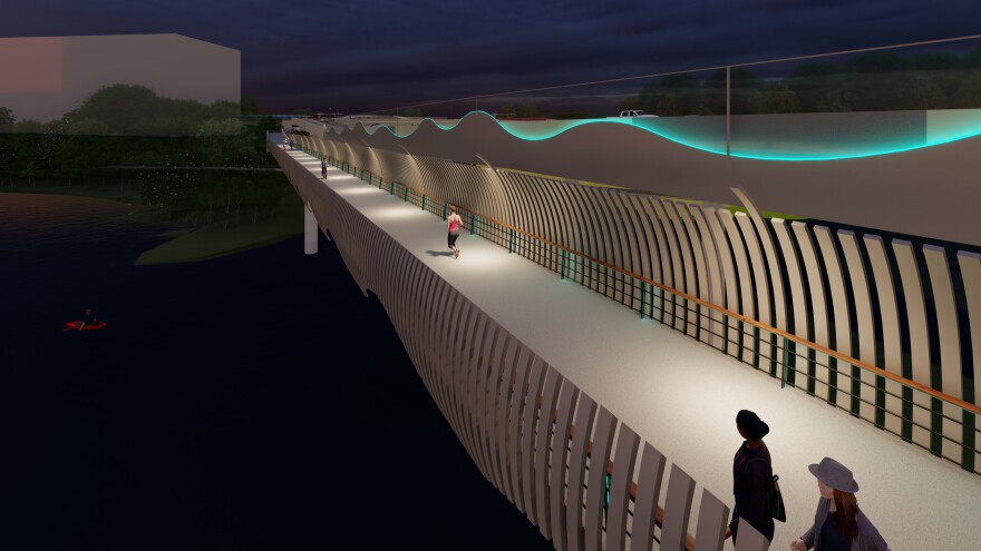
An illustration of the shared-use path along the side of the new I-35 bridge over Lady Bird Lake. A long green light runs the span. A woman is jogging down the path.

TxDOT. A proposed look for a pedestrian bridge crossing the new I-35 bridge at Lady Bird Lake. The walkway would be wider than it is now and lower than the main lanes.

On the east side of the bridge, the walkway would be a stand-alone bridge connected to the Butler Hike and Bike Trail and maintained by the Trail Conservancy.
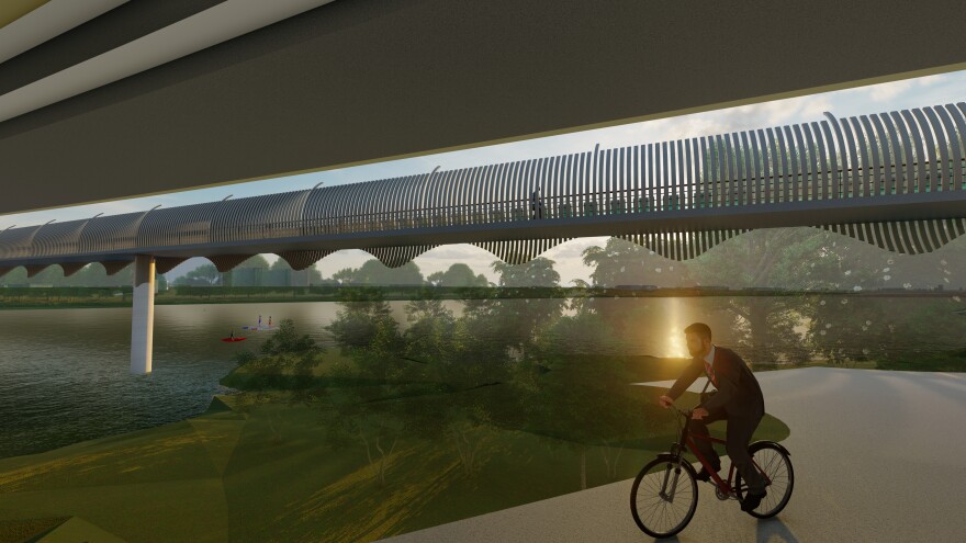
An illustration depicting a view from under the I-35 bridge showing the standalone pedestrian bridge across Lady Bird Lake. A man is riding a bicycle along a trail.

TxDOT. TxDOT plans to build a stand-alone pedestrian bridge crossing Lady Bird Lake on the east side of the I-35 bridge.

The north shore of Lady Bird Lake near the I-35 bridge will be used to store highway building machines and materials. Some of that is shown in pink in this image.

A schematic view of I-35 as it reaches the north shores of Lady Bird Lake.

TxDOT. More than an acre of Waller Beach and part of Edward Rendon Park will be used to store construction materials and as a launching pad for rebuilding the I-35 bridge.

More than an acre of Waller Beach will be used for long-term construction staging. Some of Edward Rendon Park will be used, too, but for less than six months.

After the project is done, TxDOT will own the 1.3 acres of Waller Beach. The state has vowed to return the property to parkland, but will close the area for bridge maintenance when needed.

The change means the Ann and Roy Butler Hike and Bike Trail will be detoured for at least six years to East Avenue, which runs under I-35.
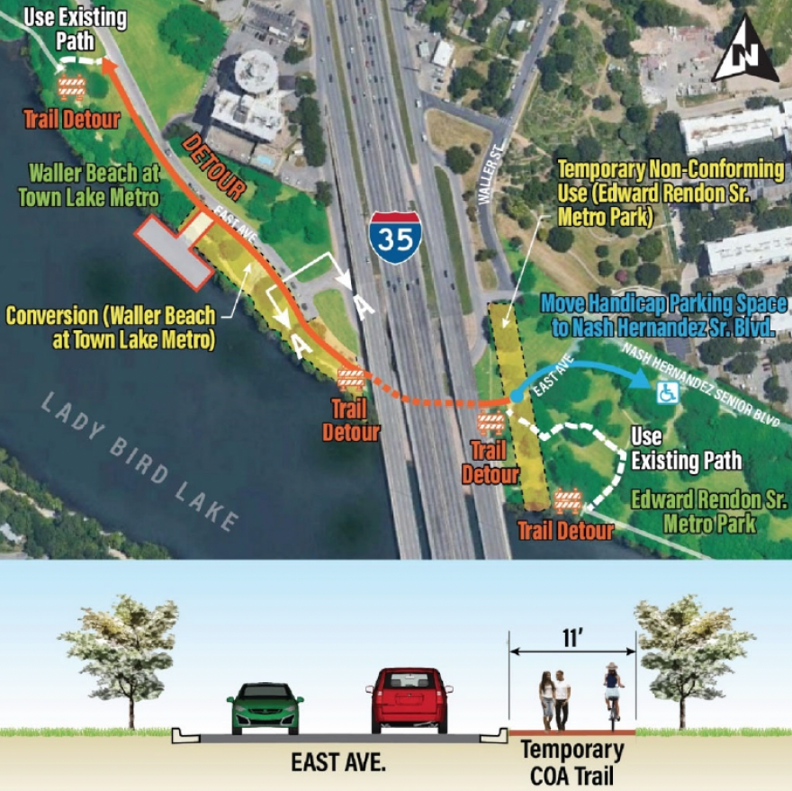
An overhead image showing the trail detour under the I-35 bridge. Underneath is a cross-section showing how the temporary city of Austin trail would be off-street and be 11 feet wide.

TxDOT. A long-term trail detour will be in effect as TxDOT uses the construction staging area on Waller Beach for at least six years.

During bridge construction, TxDOT would restrict access to about 25 acres of Lady Bird Lake itself, stopping people from any recreational boating near work crews. The lake closures would be off-and-on, depending on whether “active construction” is underway.

Parking along East Avenue would sometimes be restricted during construction. A boat ramp would be closed, too. TxDOT says it would build a construction dock off the north shore of Lady Bird Lake that would be open to the public when the project is complete.

As I-35 approaches Holly Street, the northbound frontage roads would rise up and over the highway to join with the southbound frontage roads on the east side of the highway.

A schematic view showing I-35 near Holly Street. Towards the left of the image, the northbound frontage roads are shown crossing to the west side of the highway.

TxDOT. The Holly Street crossing would go over the highway instead of under it.

Southbound traffic would be able to exit and take a U-turn ramp over the highway to get on the northbound frontage road before it crosses over the interstate.

An illustration showing the Holly Street Bridge over lowered I-35 lanes. A turnaround lane allows southbound mainlane traffic to exit to the northbound frontage road. In the distance, the northbound frontage road is shown crossing over the highway.

TxDOT. An illustration of the Holly Street bridge over I-35. The main lanes of the highway would be lowered 30 to 40 feet beneath ground level starting just before Holly Street. A U-turn lane would allow southbound main lanes to access the northbound frontage road.

Under the latest version of the plans, which TxDOT has been working on with the city, there could be a smaller cap – known as a “stitch” – next to Holly Street. The stitch would add an acre of space on top of the highway. This area, shaded in blue below, would again be at the city’s expense. Starting with this illustration, we’ll be switching occasionally to a different TxDOT schematic showing the location of these caps and stitches.

A schematic showing the location of a possible smaller cap called a "stitch" south of the Holly Street bridge.

TxDOT. TxDOT would build a smaller deck known as a “stitch” next to the Holly Street bridge if Austin will shell out millions to pay for the structure.

Under the most expensive plan, I-35 would be covered from Cesar Chavez to Seventh streets, from 11th to 12th streets, from 15th to Dean Keeton streets and from 38th 1/2 Street to Airport Boulevard. Caps are more expensive, not just because they’re larger, but also because they require fire suppression and ventilation equipment.
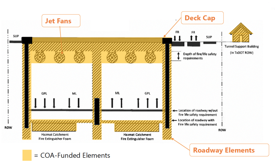
A diagram of a tunnel cross-section with different parts labeled. At the top, there are "Jet Fans" which are fans used to move air. On the right side, there's a "Tunnel Support Building" which would be for maintenance or control purposes. Below the "Jet Fans," there are three lanes marked "GPL," which stands for general purpose lanes and two lanes in the middle marked "ML" for managed lanes. Along the bottom, there's a note saying "COA-Funded Elements," which means the city is paying for those parts. There's also a "Hazmat Catchment Fire Extinguisher Foam" area.

City of Austin. Any covering over I-35 more than 300 feet long is considered a “cap” and would require ventilation and fire suppression equipment.

Stitches, which don’t require fire extinguisher foam or jet fans, could be built at Holly, 32nd and 51st streets. And there could be another stitch downtown. Look at this.

A high-level view showing possible caps covering Cesar Chavez to 7th Street. Another cap would be installed between 11th and 12th Streets. UT-Austin is considering covering the highway from 15th Street to Dean Keeton. A smaller stitch is possible at 32nd Street. And the last cap would stretch from 38 1/2 Street to Airport Boulevard.

City of Austin. The highway could be covered with a series of caps and stitches downtown, effectively putting I-35 into a tunnel and creating new downtown real estate that might be able to support buildings.

You may notice around Third Street, the cap seems to poke out a bit. Here’s a closer view.
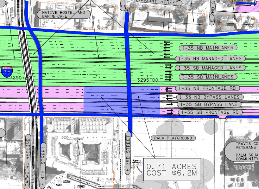
A schematic showing a blue rectangle covering part of the I-35 frontage roads near third street.

TxDOT. In this schematic, the shaded green area depicts a cap covering the sunken lanes of I-35. The blue rectangle near Third Street is a proposed pedestrian bridge. The frontage road lanes would dip beneath this ground-level bridge and the train tracks just to the north.

The blue section would be a pedestrian bridge, again at the city’s expense, that could extend west over the frontage roads, creating more walkable public space. The frontage roads would dip underneath the small stitch. The lanes would remain depressed until after they go underneath Capital Metro’s train tracks a little farther north.

TxDOT has created some renderings of what the highway could look like after it’s lowered and covered. Here’s a conceptual illustration of Cesar Chavez.
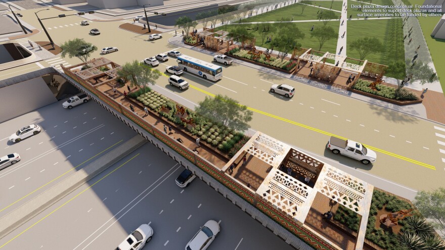
An illustration showing what a cap north of Cesar Chavez could look like. In this image, the cap is covered with a park. The Cesar Chavez bridge over I-35 includes shade structures, benches and landscaping.

TxDOT. The city hasn’t decided if it can pay for the caps over I-35, let alone what to put on them. This conceptual illustration shows what a park might look like if the city ponies up hundreds of millions of dollars to cover the newly trenched highway.

The city of Austin is still figuring out how to pay for the caps. Late last year, Council gave TxDOT $15 million to start the early design work. Another $19 million will be needed to finish the designs. A final price tag for construction will depend on what’s on top of the caps.

The upper end of the price tag was estimated at $881 million as of November, but the cost could be even higher if the city delays construction.

Where will the money come from? Everything is on the table, including federal loans and grants, a bond election, philanthropy or even reaping higher property taxes from the expected increase in real estate values next to the caps.

In this illustration of I-35 at Sixth Street, the caps are shown as a public park space. But TxDOT and Mayor Kirk Watson have talked about caps strong enough to support buildings at least two stories tall.
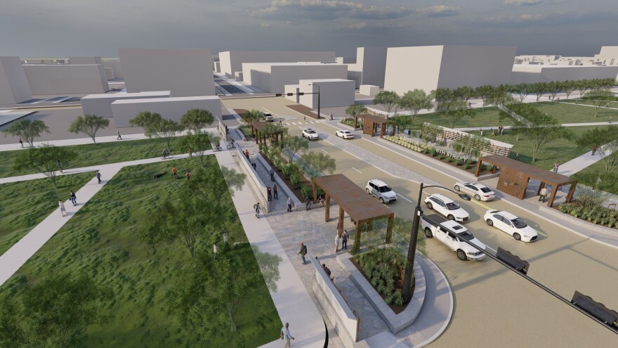
A rendering showing I-35 at 6th Street if caps are installed. The mainlanes of the highway are not visible. Instead, they're covered with parkland.

TxDOT. I-35 at Sixth Street would look radically different if Austin can find the cash to install caps over the highway. This conceptual illustration doesn’t reflect any specific plan for what would go on the caps. It’s just an idea floated by TxDOT.

Another dramatic change for I-35 would be running the northbound and southbound frontage roads side-by-side downtown from Cesar Chavez to 15th streets. TxDOT debuted this concept in January 2022.

The agency said it was listening to criticism from anti-I-35 expansion group Rethink35, which has called for replacing the interstate with a transit-friendly boulevard. Rethink35 has said TxDOT’s boulevard concept is a sham that ignores their concerns about expanding the highway.

An illustration showing northbound and southbound frontage roads running side-by-side in downtown Austin. The highway is depicted with caps on top that have a plain-looking green space.

TxDOT. The northbound and southbound frontage roads would run side-by-side through much of downtown Austin. This TxDOT illustration from early 2022 attempts to show what that could look like if the highway were covered.

After 15th Street, the frontage roads would pass over the highway together and run next to each other on the east side of I-35 until Dean Keeton Street. Here’s an overhead of what that would look like south of Martin Luther King Jr. Boulevard.
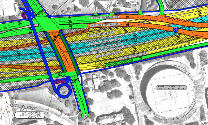
A schematic showing the frontage roads crossing I-35 north of 15th Street and reaching the east side of I-35 before the Martin Luther King Jr. Boulevard bridge over the highway.

TxDOT. Northbound and southbound frontage roads would cross together over I-35 north of 15th Street and land just south of Martin Luther King Jr. Boulevard. The cross-hatching in the schematic is supposed to represent a possible cap over the main lanes of the highway.


MLK Jr. Boulevard to U.S. 290 East

A drone image of the MLK Jr. Boulevard bridge over I-35. The upper decks can be seen in the distance.

Nathan Bernier/KUT News. Work is set to begin this year to replace the Martin Luther King Jr. Boulevard bridge over I-35.

The first crossing over I-35 to get a major overhaul would be the Martin Luther King Jr. Boulevard bridge. Work is scheduled to start this year to widen the span, including 10-foot-wide sidewalks and a 20-foot-wide buffer between pedestrians and cars.
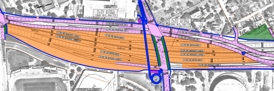
A schematic showing how UT-Austin's caps could cover the mainlanes of the highway from north of 15th Street — where the frontage roads cross the interstate — to Clyde Littlefield Drive and Manor Road.

TxDOT. UT Austin’s caps, shown in orange, would create 17 new acres of space over the highway. The caps could extend as far as Dean Keeton Street.

UT Austin’s proposed caps, shown as orange in the caps schematic, would start just south of the MLK Jr. Boulevard bridge. Those caps could reach as far as Dean Keeton Street. A separate pedestrian bridge over the caps is planned to run alongside Martin Luther King Jr. Boulevard.

This would also be one of the widest sections of new highway, with some 22 lanes, including ramps, bridges and frontage roads.

A schematic showing I-35 near the MLK Jr. Boulevard bridge, one of the widest sections of the highway.

TxDOT. The area north of the MLK Jr. Boulevard bridge would be one of the widest sections of I-35, growing from 16 to 22 lanes including frontage roads. The cross-hatching in the image shows where UT Austin’s caps could go – if the university will pay for them.

TxDOT is in conversation with the University of Texas over the design and cost of the caps. Both have been tight-lipped about the details. If UT does the full buildout, the new caps would add 17 acres of space to and more closely connect the campus grounds now split by the highway.
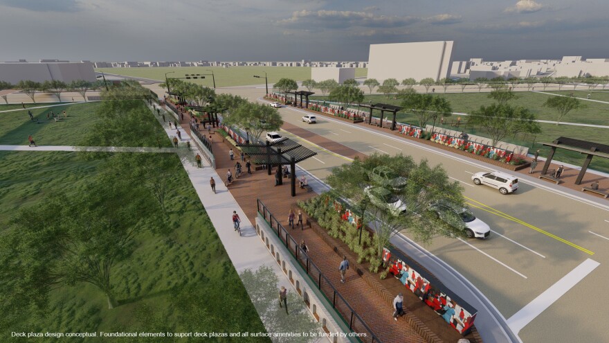
A busy street with multiple lanes for vehicles and dedicated crosswalks for pedestrians. I-35's lanes can't be seen anywhere. On the sides of the streets, there are green spaces with trees, and a small park area is visible. There's a bus stop with people waiting. A cyclist is riding in a bike lane.

TxDOT. This is TxDOT’s vision of what I-35 at MLK Jr. Boulevard might look like if UT pays for caps. The university wouldn’t necessarily be limited only to putting parks on the caps. The caps could potentially hold buildings. The stronger the caps, the more they’d cost.

UT’s caps could continue as far as Dean Keeton. Exactly what the final result looks like will depend largely on how much money the university wants to spend covering the highway.

An illustration showing I-35 frontage roads at Dean Keeton if UT-Austin pays to install caps over the highway. The mainlanes are not visible in the illustration.

TxDOT. A possible depiction of I-35 at Dean Keeton Street if UT foots the bill for hundreds of millions in caps.

By Dean Keeton, the main lanes of I-35 would run directly under the frontage roads, as you can see in this cross-section.
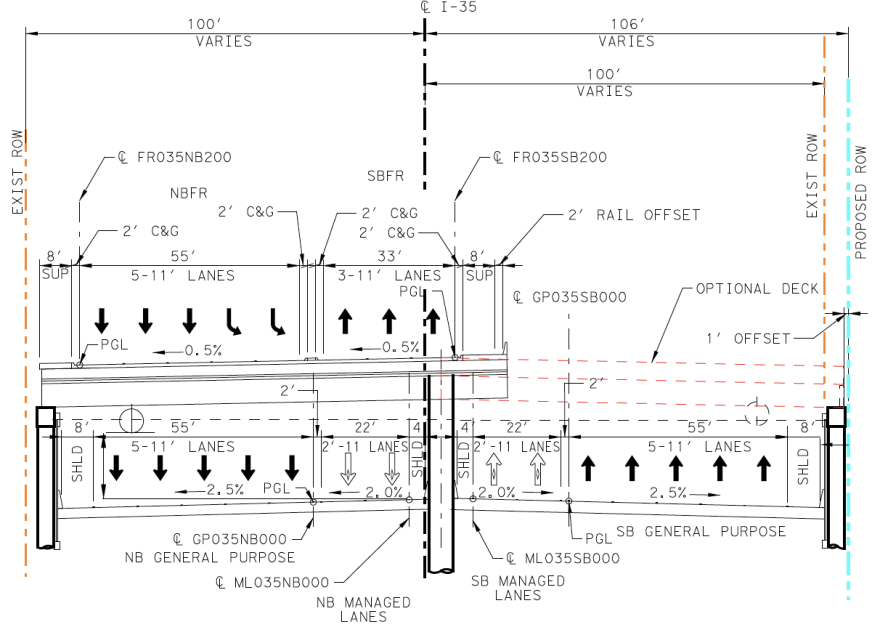
A technical drawing showing a cross-section of I-35 at Dean Keeton. The frontage road lanes, running side-by-side, would be directly above the northbound mainlanes of I-35.

TxDOT. A technical drawing showing a cross-section of I-35 at Dean Keeton. The frontage road lanes, running side-by-side, would be directly above the northbound main lanes of I-35.

North of Dean Keeton, the frontage roads would go their separate ways. The southbound access lanes would switch back over to the west side of I-35.

At 32nd Street, the city could pay for another stitch to widen TxDOT’s bridge. The cost of this 0.65-acre stitch – shown as a shaded blue area below – is estimated at $5.7 million, not including any amenities on top.
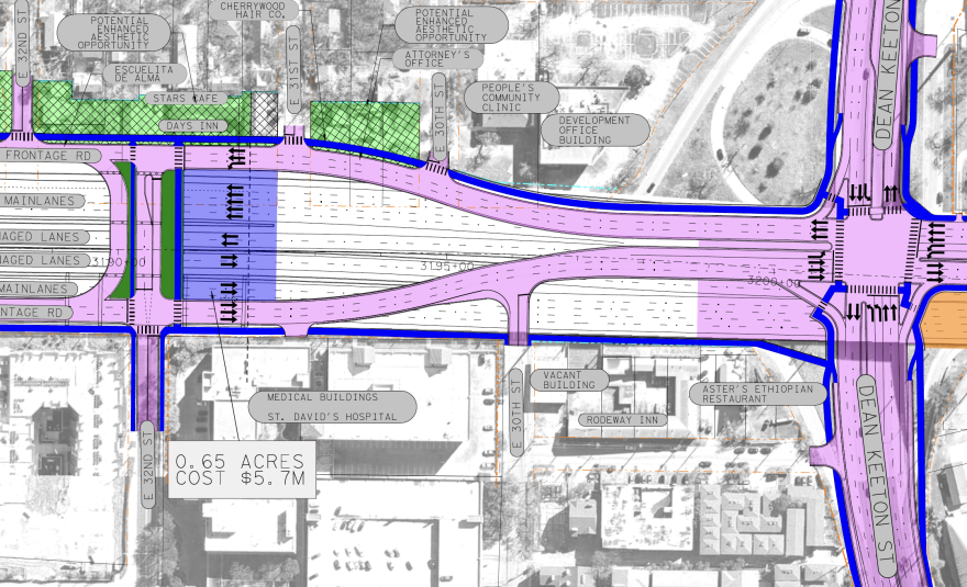
A schematic image showing the frontage roads splitting north of Dean Keeton. The southbound frontage road returns to the west side of the highway. A shaded blue stitch is shown jutting out southward from the 32nd Street bridge. The thatched green "potential enhanced aesthetic opportunity" could include landscaping, benches and shade structures, similar to other pedestrian areas of the project.

TxDOT. A schematic image showing the pink frontage roads splitting north of Dean Keeton. A shaded blue stitch is shown jutting out southward from the 32nd Street bridge. The thatched green “potential enhanced aesthetic opportunity” could include landscaping, benches and shade structures, similar to other pedestrian areas of the project.

One of the signature features of the I-35 CapEx Central project is the plan to remove the upper decks, which opened in 1975. Removing the stacked lanes and widening the highway would result in the largest number of homes and businesses forced to move anywhere along the 8-mile project.

From 30th Street to Airport Boulevard, the highway would expand eastward, pushing out dozens of homes and businesses including a 22-unit apartment building, a Spanish immersion day care, a coffee shop that opened only a year ago and a famous crystal store.

A drone image of Progress Coffee from above with the northbound upper deck in the foreground.

Nathan Bernier/KUT. Progress Coffee opened in February 2023 on the I-35 northbound frontage road near Concordia Avenue. The locally owned cafe is among a string of homes and businesses next to the upper decks that are set to be torn down so the highway can be expanded.

Access ramps on and off the managed lanes would be constructed between 32nd Street and Concordia Avenue.
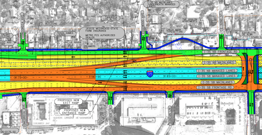
A schematic showing the lane configuration between 32nd Street and Concordia Avenue. Southbound traffic could exit the managed lanes to the frontage road. Northbound traffic would be able to get on the managed lanes.

TxDOT. Another “wishbone” ramp allowing access to and from the managed lanes from the frontage roads. Between 32nd Street and Concordia Avenue, southbound traffic could exit the managed lanes and northbound frontage road traffic could get on.

The main lanes in this area would be lowered but the managed lanes would be at about ground level, as shown in this cross section.

A cross-section of I-35 near Concordia Avenue, showing depressed mainlanes on either side of the managed lanes, which are elevated to about ground level.

TxDOT. This cross-section of I-35 near Concordia Avenue shows how the main lanes would be lowered on either side of the managed lanes, which would be at about ground level. But those HOV lanes would dip down under a cap starting at 38th 1/2 Street.

The northernmost cap in the I-35 CapEx Central project would stretch from 38th 1/2 Street almost to Airport Boulevard.

Capital Metro’s train tracks would cross over I-35 at ground level. TxDOT is planning to build a temporary rail bridge before the lanes are lowered and then excavate around the rail bridge’s pillars to create space for the sunken lanes.

An overhead schematic of I-35 showing a cap between 38 1/2 Street and Airport Boulevard. Widened bridges would be constructed at 38 1/2 Street and 41st Street. CapMetro's train tracks would pass diagonally over the mainlanes at ground level.

TxDOT. The shaded green area in this overhead schematic represents a cap covering the lowered main lanes of I-35 from 38th 1/2 Street almost to Airport Boulevard. Widened bridges would be constructed at 38th 1/2 Street and 41st Street. Capital Metro’s train tracks would pass diagonally over the main lanes at ground level.

The second single-point urban interchange for the I-35 CapEx Central project would be at Airport Boulevard. TxDOT hasn’t yet finalized the plans for this SPUI.

One animated rendering showed a pedestrian tunnel under the highway. The state agency received some feedback from people concerned the tunnels could be unsafe at night, so engineers are rethinking how to configure the pedestrian paths.
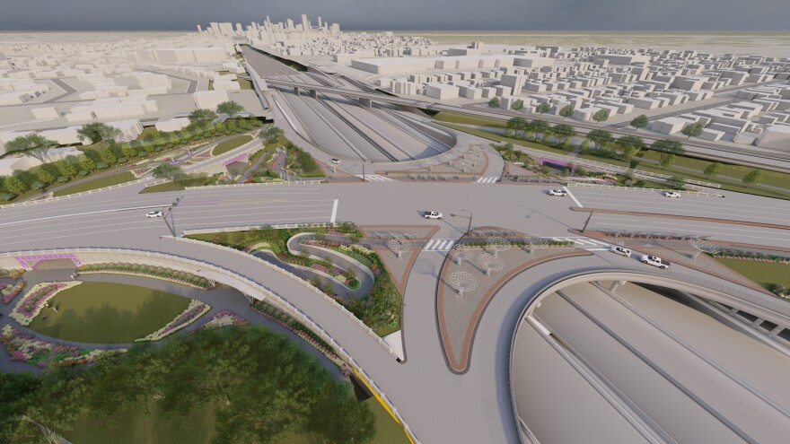
A stripped down depiction of the Airport Boulevard interchange over I-35. CapMetro's rail bridge is seen in the distance, but the optional city-funded cap from 38 1/2 Street to Airport is not shown.

TxDOT. A stripped-down depiction of the Airport Boulevard interchange over I-35. Capital Metro’s rail bridge is seen in the distance, but the optional city-funded cap from 38th 1/2 Street to Airport Boulevard is not shown.

North of Airport Boulevard, the main lanes of I-35 would come back up to ground level. At this point, drivers would have another opportunity to get on and off the managed lanes.

TxDOT would also install northbound and southbound bypass lanes. These would allow people on the frontage roads to skip past the interchange at Airport Boulevard.
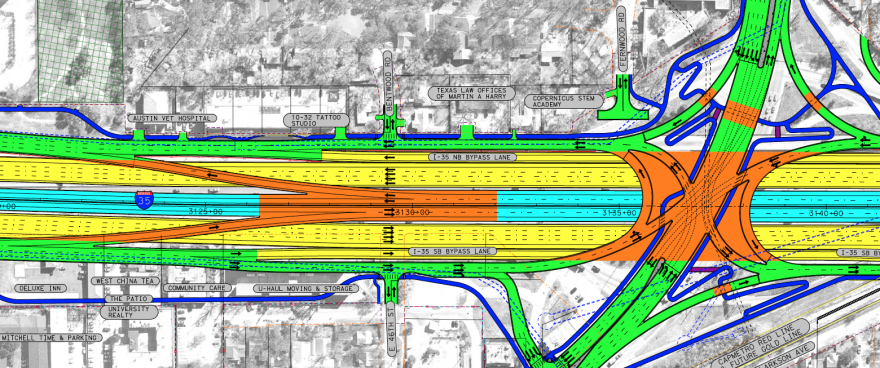
A schematic view showing how the configuration of lanes north of Airport Boulevard. Another wishbone ramp would allow northbound drivers to exit the managed lanes and southbound drivers to get on.

TxDOT. Drivers on the northbound managed lane could exit north of Airport Boulevard. Southbound drivers could get on the managed lanes. This is another area where a significant number of homes and businesses will be driven out by the highway expansion, only this time, it would be on the west side of the interstate.

The west side of I-35 north of Airport Boulevard would have the second-most displacements of any section of the project. About a dozen businesses, including a Deluxe Inn Motel, would be pushed out. An apartment building with 22 units – part of the Village at 47th complex – would be torn down to create space for a construction staging area.

An aerial view of a two-story apartment building behind West China Tea House. The building is tan and beige. A parking lot is out front. I-35 can be seen on the left side of the photo. In the distance, the downtown Austin skyline is visible.

Nathan Bernier/KUT. This two-story apartment building behind West China Tea House is part of the Village at 47th apartment complex. At first, TxDOT didn’t realized anyone was living there. The apartment building and the West China Tea House will be destroyed for the highway project.

At 51st Street, you’ll find the northernmost stitch in the project. This would be about 1.3 acres, if the city can afford it. The 51st Street roundabout, which opened in 2018, would stay.

A schematic showing a possible stitch installed at the 51st Street bridge, jutting out northward.

TxDOT. The shaded blue area in this overhead image, pulled from TxDOT’s schematic of possible cap locations, shows a possible stitch or pedestrian bridge extending from the 51st Street bridge. This, too, would have to be paid for by the city of Austin.

Next to the Capital Plaza Shopping Center, all lanes of I-35 would be at ground level. A 75-foot-wide pedestrian bridge is planned to cross the highway. TxDOT would pay for this one.

An overhead schematic showing a pedestrian crossing over I-35 at Chase Bank near Capital Plaza.

TxDOT. The dark blue rectangle represents a 75-foot-wide pedestrian bridge over I-35 at Chase Bank near Capital Plaza. The blue sidewalk switching back is a ramp up to the bridge. The purple lines are staircases. The shaded purple blob to the right is a 100-year flood zone.

We’ve reached the northern end of the I-35 CapEx Central project at U.S. 290 East. This is where an expansion of I-35 north to the Travis-Williamson County line begins. That project, dubbed I-35 CapEx North, is already under construction and includes adding one managed lane in each direction.

If you squint and look closely, you might notice there’s only one managed lane south of U.S. 290 East. The second managed lane doesn’t begin until farther south, closer to Airport Boulevard. People getting onto I-35 southbound from U.S. 290 East would have to drive about a mile before they could get on the HOV lanes.
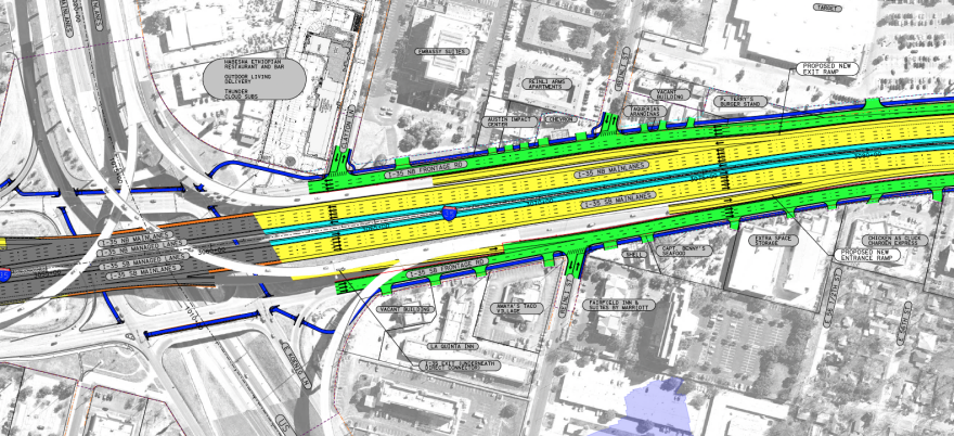
A schematic showing the I-35 expansion from East 56th Street to U.S. 290 East.

TxDOT. The I-35 CapEx Central project ends at U.S. 290 East, but connects with a project to add one managed lane in each direction north to the Travis County line.


When will this happen?

TxDOT plans to start work this year on the section spanning from Ben White Boulevard to Lady Bird Lake. Construction is also slated to begin this year on the Martin Luther King Jr. Boulevard bridge and pedestrian crossing.
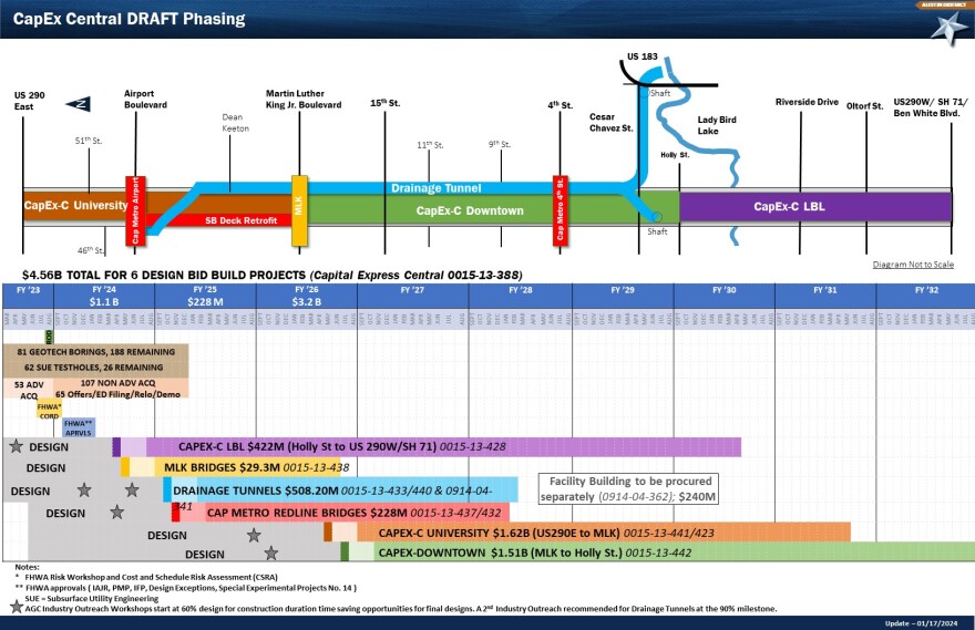
A graph showing the approximate construction timeline for the I-35 CapEx Central Project.

TxDOT. The latest construction timeline from TxDOT – updated Jan. 14, 2024 – shows how the construction will be staggered along the 8-mile project. The bar graph along the bottom indicates with a small dark rectangle when construction companies could start bidding on projects. The color gets lighter for the period before construction. The long dark bar shows when construction would occur.

The effort to tear down the upper decks, start burrowing tunnels for the new drainage system and build Capital Metro rail bridges is scheduled to start next year.

Work from Holly Street to U.S. 290 East was planned to begin in late 2026. Some structures could be torn down sooner to create space for construction staging.

This story was produced as part of the Austin Monitor’s reporting partnership with KUT.

The Austin Monitor’s work is made possible by donations from the community. Though our reporting covers donors from time to time, we are careful to keep business and editorial efforts separate while maintaining transparency. A complete list of donors is available here, and our code of ethics is explained here.

You're a community leader

And we’re honored you look to us for serious, in-depth news. You know a strong community needs local and dedicated watchdog reporting. We’re here for you and that won’t change. Now will you take the powerful next step and support our nonprofit news organization?

Back to Top